Courtesy of Rooster Realty, LLC


Property Description
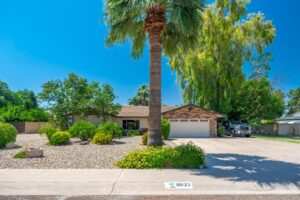
464 wooded acres, fronting State Route 61, across from Eagle Ridge just 10 miles east of the Show Low Airport in Apache County. This dense tree covered terrain enjoys both flat meadow-land and rolling hillside with spectacular views for miles. Utilities to the property include Cedar Groove Water, Navopache Electric and Frontier Telephone. The property shape is square (a section) less the 64 acres in the southeast corner, which houses Eagle Ridge, a fully developed new home community. This breathtaking property offers seclusion, with the convenience of being just 10 minutes from downtown Show Low. 4000+ foot window on SR61 west of the Eagle Ridge subdivision- Residential & Commercial Opportunities Gently sloping treed terrain with Mountain Views 10 minutes to airport and Show Low Selle
Open House
Property Details and Features
-
Building
- Other structures: “None”
-
Fence
- “Wire”
-
Listing
- Listing ID: 6730043
- Standard status: Active
- 208 days on market
-
Lot
- 317.48 acres
- 13,829,309 sqft
- “East/West Exposure”
- “Mountain View(s)”
- “North/South Exp”
-
Property
- Zoning: AG
-
Taxes
- Annual amount: $5,000
- Lot: –
-
Utilities
- “Other (See Rmks)”
Property Map
Street View
Market Trends for 85940, Vernon, AZ
Nearby Schools
Request More Information
Schedule a Showing
Similar Properties Nearby
This content last updated on February 5, 2025 1:06PM. Some properties which appear for sale on this web site may subsequently have sold or may no longer be available.